Waterworld – The Earth Has Seen It Before
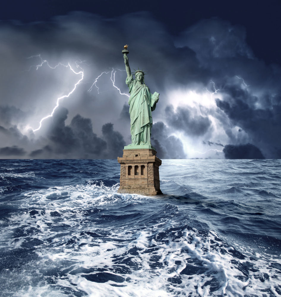 Waterworld is a 1995 American post-apocalyptic science fiction action film starring Kevin Costner. The setting of the film is in the distant future. Although no exact date was given in the film itself, it has been suggested that it takes place in 2500. The polar ice caps have completely melted, and the sea level has risen over 7,600 m (25,000 feet), covering nearly all of the land. The plot of the film centers on an otherwise nameless antihero, “The Mariner”, a drifter who sails the Earth in his trimaran. The most expensive film ever made at the time, Waterworld was released to mixed reviews, praising the futuristic setting and premise but criticizing the characterization and acting performances.
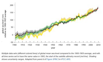
It is a fact that global sea level has been rising over the past century, and the rate has increased in recent decades. In 2014, global sea level was 2.6 inches above the 1993 average—the highest annual average in the satellite record (1993-present). Sea level continues to rise at a rate of about one-eighth of an inch per year.
The two major causes of global sea level rise are thermal expansion caused by warming of the ocean (since water expands as it warms) and increased melting of land-based ice, such as glaciers and ice sheets. The oceans are absorbing more than 90 percent of the increased atmospheric heat associated with emissions from human activity so following global warming doctrines it is this that has been blamed for both global warming and the rising sea levels.
With continued ocean and atmospheric warming, sea levels will likely rise for many centuries at rates higher than that of the current century. Undoubtedly it is an issue, in the United States, almost 40% of the population lives in relatively high-population-density coastal areas, where sea level plays a role in flooding, shoreline erosion, and hazards from storms. Globally, eight of the world’s 10 largest cities are near a coast, according to the U.N. Atlas of the Oceans.
But we are also duty bound to look at this process in the context of Geological not just Anthropomorphic time. Since scientists first began seeking sea level measures more than 200 years ago, their methods have come a long way. But that is the extent of the increasingly accurate measure of global sea levels.
And what does it show us well it confirms that global sea levels have been rising steadily for the last 200 years. Should we be concerned, is it unusual? Well those are two separate questions that should also be answered separately.
Should we be concerned, well yes with such a large proportion of global citizens living in mega cities close to the coast there is cause for concern. But then living close to a coastline also has its other unrelated dangers as recent history testifies such as the Banda Aceh tsunami of 2004 and the Japanese tsunami of 2011. There are also cities close to active volcanoes such as Tokyo and Mount Fuji and also those close to major earth fractures in earthquake prone zones such as Los Angeles and San Francisco. So the list of concerns is not just restricted to global sea level rise, the earth is a dynamic place and is full of dangers. Just as global sea levels presently are rising it is a fact also that someday Mount Fuji will again erupt and will cause widespread damage and disruption. There will also be earthquakes in Los Angeles and in San Francisco, the question is not if it is when.
Going back to global sea Ievel rising is it unusual? The history of complex life on earth goes back some 580 million years. Hominids (or Humans) have only been around for 6 million years (about 1% of that history). We have accurate global sea level records for only 200 years. A 5% sample would be 29 Ma so 200 years is far from statistically viable so what can we do to measure it?
Oxygen isotope ratios (d18O) provide a potential means for reconstructing sea-level change over the past 100 Myr. d18O values reflect the effects of temperature and ice-volume (hence sea level) changes in the shells of single-celled organisms called foraminifera. By calibrating foraminiferal d18O variations to the reef terrace record, geologists can make an estimate of global sea-level changes. However, it is difficult to extend oxygen isotopic sea-level estimates beyond the past million years because the temperature history of the planet prior to this is less well known. In addition, diagenetic alteration potentially overprints Late Cretaceous to early Tertiary d18O values (ca. 100–25 MyBP), whereas records older than 100 Myr are typically altered.
Our primary information on sea-level change prior to the Quaternary (>2 My BP) is derived from stratigraphic records of continental inundation. Transgressions have flooded the continents on roughly 100-Myr timescales, reflecting changes in the rates of ocean crust production. Finer-scale cycles (1–10 Myr) have been attributed either to sea-level change or to tectonic controls. These cycles are observed in the sediment and rock record with deeper water environments representing transgressions and shallower water environments representing regressions.
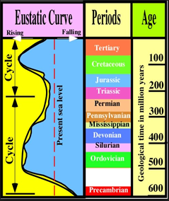
What the above figure shows us is that present day sea levels are historically low for the period of complex life on Earth so just like a recent stock market crash there is only one direction for it to go. So where can we find Waterworld. Sea level during the Cretaceous (144–65 Ma) was much higher than at present because of long-term changes in sea level. These long-term (10–100 Myr scale) sea-level changes have been largely controlled by tectonics. For example, during the warm interval of the Middle Cretaceous (ca. 80–90 Ma), global sea level was between 100 and 170 m higher than today. However, such high sea levels cannot be explained by a warmer planet and the absence of ice sheets: even if all of the modern ice sheets were melted (an “ice-free Greenhouse world”), then sea-level would be only 73 m higher than today. Although the Cretaceous oceans were 10–12°C warmer than today, thermal expansion could only account for another 10–13 m of rise. The generally accepted explanation for the high mid-Cretaceous sea levels is high sea-floor spreading rates; higher rates mean hotter crust, which expands, displacing seawater and causing long term flooding of the continents. This pulse of mid-Cretaceous high seafloor spreading has been recently disputed, though various stratigraphic data unequivocally show that relative to the continents, sea level was 100–250 m higher, based on backstripping in the former case and continental flooding in the latter. If not caused by high-sea floor spreading rates, the long-term flooding and subsequent retreat of the sea over the past 180 Myr could have been the result of the breakup of the supercontinent Pangea, beginning at 180 Ma, which may have led to overall subsidence of continents relative to the oceans during the Jurassic to mid-Cretaceous (Miller 2006).
In the movie Waterworld dirt is traded as a rare commodity and there is a reverent mythological belief that somewhere there is a ‘dryland’ that exists. It is interesting that this almost biblical flood during the Middle to Late Cretaceous period coincides with the last evolutionary push by the dinosaurs to super giant status. The announcement of a find in 2014 sums it up somewhat nicely. ‘The word big does not do justice to a massive, long-necked dinosaur that shook the Earth in Argentina about 77 million years ago. Try colossal, enormous, gargantuan and stupendous – and you might come close to an accurate description of this behemoth, known to scientists as Dreadnoughtus schrani. Scientists on Thursday announced the discovery in southern Patagonia of remarkably complete and well-preserved fossil remains of the dinosaur, which weighed 65 tons (59,300 kg) and measured 85 feet long (26 meters) with a neck 37 feet long (11.3 meters) and a tail 30 feet long (8.7 meters). Dreadnoughtus weighed more than an adult sperm whale or a herd of African elephants. Tipping the scales at seven times as much as the dinosaur T. rex, it made the North American menace that also lived during the Cretaceous Period look puny’. Dreadnoughtus had “the largest reliably calculable weight” of any known land animal – dinosaur or otherwise. Scientists have us believe that the dinosaurs were finally wiped out by a meteorite striking the Earth at 65 million years ago approximating to the end of the Cretaceous Period. Maybe an alternative theory following the Waterworld theme is that they simply ran out of dirt and that mythological dry land just did not exist.
Studies at Exxon Production Research Company (EPR) revolutionized our view of the stratigraphic record of sea-level change. Sea level falls and tectonic changes both produce erosion surfaces termed “unconformities”; packages of sediments on continental margins bracketed by unconformities are called “sequences.” Researchers at EPR made a revolutionary breakthrough in using seismic reflection profiles to identify sequences and then using these sequences to estimate the ages and magnitudes of past sea level changes (Haq et al., 1987; Vail et al., 1977). These estimates proved highly controversial, in part because of the proprietary nature of the data used to construct them and in part because of flaws in the method used to estimate the amplitudes of sea-level change. Nevertheless, more than a decade of studies, described below, have been carried out, validating the general number and timing of eustatic events published by EPR – a landmark achievement. However, estimation of eustatic amplitudes remains one of the thorniest problems in geology.
For those who would like to know more about global eustatic sea level curves and the revolutionary science of sequence stratigraphy then GLOMACS is running a course in Dubai, UAE on Stratigraphy: Sequence, Seismic and Integrated Stratigraphic Analysis from the 5th to the 9th November 2017.
The course will cover an understanding of the concepts and the application of sequence and seismic stratigraphy in identifying clastic and carbonate hydrocarbon reservoirs and predicting their distribution and in optimizing exploration efforts for a company as well as obtaining the most from seismic and well data. We may also take a look at a few more of those Late Cretaceous, dinosaurs and the evidence for the meteorite strike.
Dubai - UAE
P. O. Box
74653
Tel: +971 (04) 425 0700
Fax: +971 (04) 425 0701
Tax Registration Number: 100270246000003